Multi-scale Flood Monitoring and Assessment Services for West Africa (MiFMASS)

Photo credit: sunnewsonline.com
The use of Satellite Earth Observation data to combat societal challenges around the world has continued to gain prominence particularly in the area of Disaster Monitoring, Management and Mitigation. Therefore, it is no wonder that the joint initiative of the African Union (AU) and European Union (EU), the Global Monitoring for Environment and Security and Africa (GMES & Africa), is fundamentally focused on the use of Earth Observation data by Africans, for the Africa We Want.
To facilitate this, the EU provided free access to Copernicus data and resources to develop applications, services or even adapt the existing Copernicus services to meet the needs of the region. The CSSTE Consortium, one of the beneficiaries of the GMES & Africa Support Programme- Phase 1, based in the West Africa region, identified gaps in Managing, Monitoring and Assessing Flooding disasters across the region which could be filled through Multi-scale Flood Monitoring and Assessment Services for West Africa (MiFMASS) using Sentinel data and other freely available EO data.
In the Phase 1 of the GMES & Africa support programme, 12 Consortia spread across the five (5) sub-regions of Africa were saddled with the responsibility of developing solutions using freely available EO data to tackle regional challenges that fall under any of the two thematic categories; Water and Natural Resources & the Marine and Coastal Services. CSSTE’s intervention falls under the Water and Natural Resources category. The overall objective of MIFMASS is ‘To enhance the efficiency of flood monitoring, assessment and management in West Africa by providing Earth Observation (EO) based services on real time basis to disaster management organizations and boosting their human capacity to adapt to these services’ . The CSSTE Consortium is made up of seven (7) Partner institutions from five (5) countries (Benin, Burkina Faso, Cote d’Ivoire, Ghana and Nigeria) in West Africa.
Flood disaster across West Africa is a leading cause of socio-economic problems. The statistics of Flood disaster recorded between 2000 - 2013 for the five countries that make up the Consortium shows that 11,694,975 million people were affected, with fatalities of 1,542 persons and about US$ 697 million (Nigeria and Burkina Faso alone) in assets and livelihood destroyed (ECA 2015 report).
In 2018, NADMO reported that 32 people died in Ghana as a result of floods, over 100,000 displaced. In Nigeria, NEMA recorded 141,369 displaced people, 108 deaths, 192 injured and 13,031 houses destroyed across 8 states. In June 2018 alone, the National Civil Protection Office of Ivory Coast, recorded up to 18 deaths. The increasing severity of attendant losses associated with Flood disasters despite efforts being made by mandated organizations in the region necessitated the need to bolster these efforts through EO initiatives for more robust solutions to combat this menace.

Statistics of Flood Impact between 2000-2013 (extracted from ECA report, 2015)
In its efforts to deliver on the overall objective, the Consortium successfully developed tools like the Flood Reporter App, an updatable Flood Event Database, a Geospatial Database, a Flood Damage Assessment package and a Flood Forecasting / Early Warning system to help manage, monitor and assess Floods better. In addition to the tools developed, they have also trained over 600 personnel from various National Disaster Management Organizations (DMOs) across the region to increase and enhance the capacity of a critical mass of experts in Africa on the use of Earth Observation (EO) data to improve the realization of institutional mandates and targets.
The Updatable Flood Event Database, a novel tool, was designed to be a one-stop shop data repository for regional data on flood events in recognition of the inherent challenges in accessing historical and real time flood data. It will be a very useful tool for Decision making, Research and Disaster management in the West Africa sub-region. It is well known fact that the attendant losses that follow from disasters does not stop at the socio-economic and infrastructural level but also has very huge impact on human lives. Therefore, the existence of a record database that captures the quantitative and qualitative extent of a flood event is a great tool for DMOs, governments and international organizations in providing impactful support to affected areas in the event of a disaster. The records range from the geographical location, the type of disaster (e.g., riverine or flash flood), casualties and the damage in physical and economic terms. This database can aid in the identification of hotspots and implementation of targeted interventions across the countries of interest. It can also assist in developing flood vulnerability maps using spatial layers of factors that may contribute to the occurrence of floods. The Database Architecture design by CSSTE utilized open source tools and libraries for all the development.
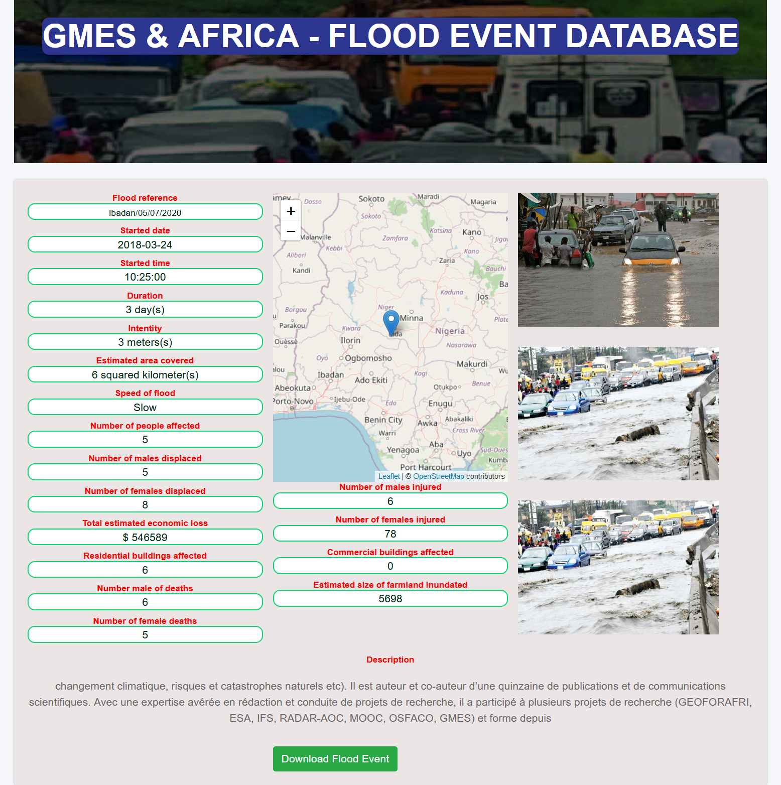
Sample search result for a Flood Event from the Database
To ensure continuous data collection for the Flood database to be regularly updated, bearing in mind that Data driven approaches like data analytics, machine learning etc in developing flood mitigation measures require a lot of historical data, a Flood Reporter Application was developed. It is an integrated application consisting of mobile and cloud service components that is designed for DMOs and the general public for reporting flood events. The application has been deployed on customized Tablet devices and distributed to mandated national organizations in the five participating countries of the sub-region to capture flood events in real time. The updatable database allows for continuous update of information on the platform via various means: crowdsourced data and data professionally collected by the National mandated organizations who the service is eventually domiciled with.
Another resourceful product that has been developed by the Consortium is the Geospatial Database. It is a complete online database for all the spatial layers downloaded, pre-processed and generated in the framework of the MIFMASS project which covers certain river basins in Ghana, Benin, Nigeria, Cote D’Ivoire and Burkina Faso and can be assessed on www.gmes-mifmass.net. The Geospatial database is useful for Disaster risk mapping and the whole Disaster management cycle. It has different spatial layers like basin boundaries, Geology, Drainage networks, Transportation/Road Network, Soil, Topography, Land use/Land cover and so on. It is a goldmine resource of information that can be harnessed by the government, industry and private organizations across various sectors for the purpose of making informed decisions.
A Flood Forecasting / Early Warning system was set up using catchment areas within five selected basins in the region; Oueme, Ogun-Osun, Black Volta, Nakanbe and Bonoumin-Palmeraie. An SMS module was also developed to deliver timely Flood alerts to people living in flood prone areas. However, access to forecasted free rainfall data proved quite challenging to fully make this service operational. The System was successfully validated using past precipitation data. It is recommended that countries invest in maintaining weather stations for local in-situ data acquisition.
The Damage Assessment Module developed is to evaluate the impact of flood in terms of property and environmental damages for each identified flood hot-spots (area at risk) in the respective five countries in West Africa. In this module, different Flood risk maps depicting roads, buildings, critical infrastructure at risk were generated, flood Extent maps and Cost Analysis. This is particularly useful for insurance companies and governments in compensating victims of Flood disasters as well as for recovery efforts / Needs Assessment. One of the Flood risk extent map generated is as shown below:
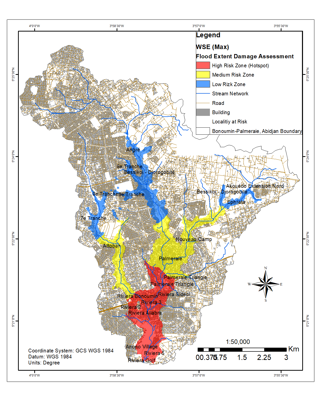
Flood Risk Extent (Hotspot) Model of Bonoumin-Palmeraie River Basin
All through the development of these various tools, the Consortium conducted 7 customized trainings for relevant personnel from Stakeholder and Partner organisations to improve their capacity in the use of EO data. It was also to engender a sense of ownership and to ensure that the tools are adopted for use by integrating them with existing solutions to deliver better on their institutional mandates.
Finally, it is not enough that these tools have been developed, it is crucial that advocacy to support the continued and deliberate use of the developed tools be made across levels of government and eventually have it expanded over the entire West Africa region for the enhancement of flood mitigation strategies. The ground work for this has been laid at the end of the phase 1 of GMES & Africa, when these tools were officially handed over to the mandated and relevant organizations in each of the five Partner countries of MIFMASS - Benin, Burkina Faso, Cote d’Ivoire, Ghana and Nigeria).
The CSSTE Consortium is made up of seven (7) Partner institutions from five (5) countries (Benin, Burkina Faso, Cote d’Ivoire, Ghana and Nigeria) in West Africa who worked together to develop the tools presented above. They are:
Centre for Space Science and Technology Education, Nigeria- Regional Implementation Centre
Institut Supérieur d’Etudes Spatiales et Télécomunications (ISESTEL), Burkina Faso
Volta Basin Authority (VBA), Burkina Faso
CSIR-Water Research Institute (CSIR-WRI), Ghana
University Of Ghana (Dept. of Earth Science), Ghana
Centre Universitaire de Recherche et d’Application en Teledetection (CURAT), University Félix Houphouët-Boigny, Cote D’ivoire
National Water Institute (NWI), Benin
These tools, newsletters and more can be accessed via the Web-Portal: www.gmes-mifmass.net.

Funmilayo ERINFOLAMI
Funmilayo is a Materials and Space Weather Scientist. She is a Scientific staff of the African Regional Centre for Space Science and Technology Education in English (ARCSSTE-E), Nigeria. A member of faculty for the Postgraduate Diploma Programme of ARCSSTE-E. She has been involved in research ranging from Small Satellite Design & Development to Disaster Coordination.
Funmilayo has contributed to different Capacity Building efforts through collaborative projects in Europe and Africa. She is an Educator and very passionate about Space Science Education. She has been named one of the top 13 Women in the African Space industry. She is a member of the Space for Health Working Group Committee of the United Nations Office for Outer Space Affairs (UNOOSA).
She served as the Secretary and Communication Officer of the CSSTE Consortium under the GMES & Africa Support Programme for the implementation of the MultiScale Flood Monitoring and Assessment Services for West Africa (MIFMASS).